Welcome Visitor. First time here? Like what you see? Bookmark us for when you are bored, and check out 'top shots' and 'fantastic (editors choice)' in the menu above, you won't be dissapointed. Join our community! click here to sign up for an account today. Sick of this message? Get rid of it by logging-in here.


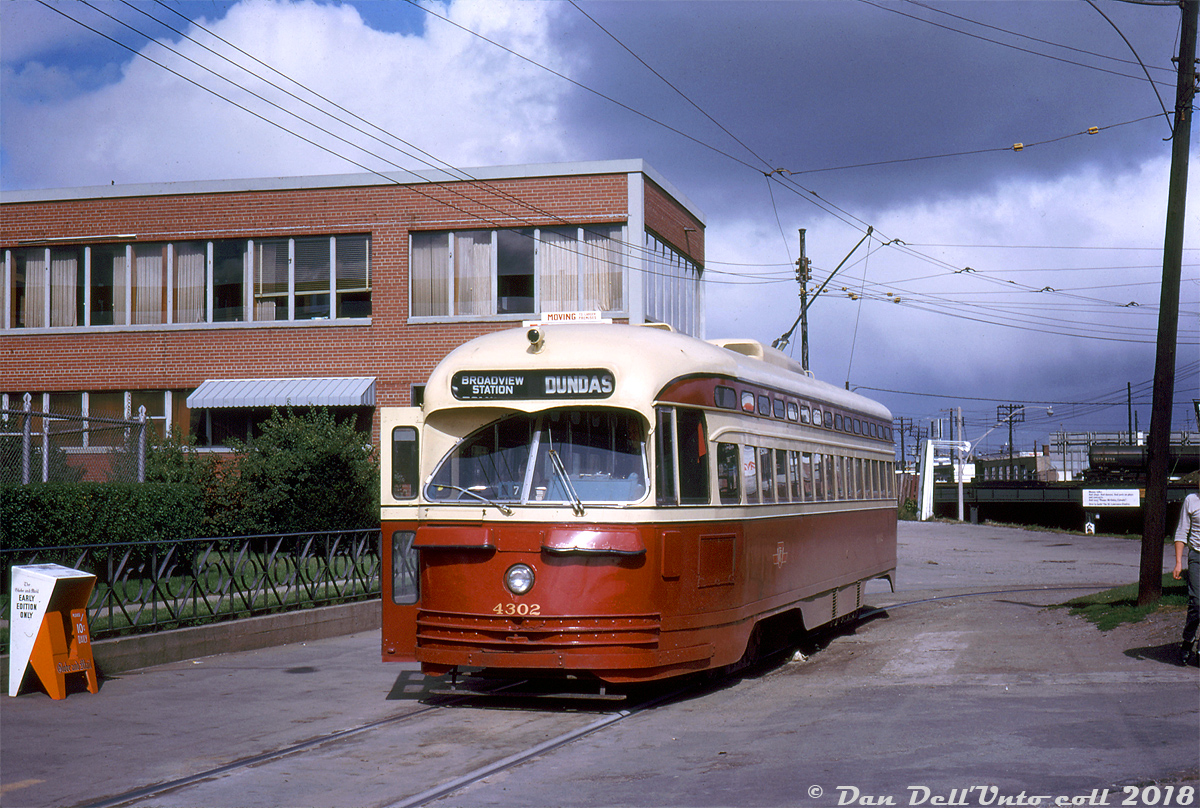
TTC PCC 4302 poses at Runnymede Loop (at the corner of Dundas Street West & Runnymede Road in the Junction area) at the end of its westbound run on the Dundas route, ready to head back east via Dundas Street all the way back to City Hall Loop. The "Broadview Subway Station" terminus exposure is either up in error or posed for photos, as the station and new Bloor-Danforth subway line was still under construction and a number of months away from seeing any streetcar service. According to Transit Toronto, the Dundas car would operate between Runnymede Loop to City Hall Loop until the subway opened in February 1966, after which every second Dundas car would run to Broadview Station. In May 1968 when the B-D subway extensions opened, the http://www.railpictures.ca/?attachment_id=35760 would be cut back to Dundas West Station and replaced by a trolleybus service, which eventually became a diesel bus that still serves Runnymede Loop today.The building in the background was home to the Dominion Bridge Company (and before that Runnymede Steel in the 50's), but at the time was in the process of "moving to larger premises" (they had other facilities in Dixie (Mississauga) and Mount Dennis (Toronto) at the time). CPR's Lambton/West Toronto yards are also visible, with a CGTX tank car spotted in the yard above the Runnymede Rd. subway (a term commonly used for underpasses/viaducts before Toronto got a real subway). And the orange newspaper box is for the Globe & Mail's Early Edition (Only) - just 10 cents on the honor system of payment.John F. Bromley photo, Dan Dell'Unto collection.
Copyright Notice: This image ©John F. Bromley photo, Dan Dell'Unto coll. all rights reserved.


Caption: TTC PCC 4302 poses at Runnymede Loop (at the corner of Dundas Street West & Runnymede Road in the Junction area) at the end of its westbound run on the Dundas route, ready to head back east via Dundas Street all the way back to City Hall Loop. The "Broadview Subway Station" terminus exposure is either up in error or posed for photos, as the station and new Bloor-Danforth subway line was still under construction and a number of months away from seeing any streetcar service. According to Transit Toronto, the Dundas car would operate between Runnymede Loop to City Hall Loop until the subway opened in February 1966, after which every second Dundas car would run to Broadview Station. In May 1968 when the B-D subway extensions opened, the Dundas streetcar would be cut back to Dundas West Station and replaced by a trolleybus service, which eventually became a diesel bus that still serves Runnymede Loop today.

The building in the background was home to the Dominion Bridge Company (and before that Runnymede Steel in the 50's), but at the time was in the process of "moving to larger premises" (they had other facilities in Dixie (Mississauga) and Mount Dennis (Toronto) at the time). CPR's Lambton/West Toronto yards are also visible, with a CGTX tank car spotted in the yard above the Runnymede Rd. subway (a term commonly used for underpasses/viaducts before Toronto got a real subway). And the orange newspaper box is for the Globe & Mail's Early Edition (Only) - just 10 cents on the honor system of payment.

John F. Bromley photo, Dan Dell'Unto collection.

Photographer:
John F. Bromley photo, Dan Dell'Unto coll. [1006] (more) (contact)
Date: 10/03/1965 (search)
Railway: Toronto Transit Commission (search)
Reporting Marks: TTC 4302 (search)
Train Symbol: Dundas (ebnd to City Hall loop) (search)
Subdivision/SNS: TTC Runnymede Loop - Dundas & Runnymede (search)
City/Town: Toronto (West Toronto) (search)
Province: Ontario (search)
Share Link: http://www.railpictures.ca/?attachment_id=36016
Click here to Log-in or Register and add your vote.

8 Favourites
Photographers like Gold.Log-in or Register to show appreciation
View count: 1808 Views

Share this image on Facebook, Twitter or email using the icons below
Photo ID: 34825

Map courtesy of Open Street Map

Full size | Suncalc


All comments must be positive in nature and abide by site rules. Anything else may be removed without warning.

One Comment
  1. October 3rd was a Sunday. Perhaps cars ran to Broadview loop rather than City Hall and Eaton’s/Simpsons.

Railpictures.ca © 2006-2024 all rights reserved. Photographs are copyright of the photographer and used with permission
Terms and conditions | About us