Welcome Visitor. First time here? Like what you see? Bookmark us for when you are bored, and check out 'top shots' and 'fantastic (editors choice)' in the menu above, you won't be dissapointed. Join our community! click here to sign up for an account today. Sick of this message? Get rid of it by logging-in here.


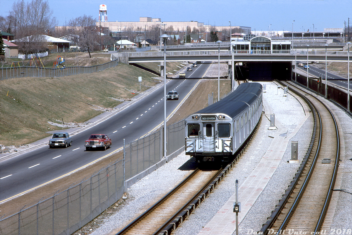
"Finch via Downtown": a 4-pack of Hawker Siddeley Canada H1 subway cars have just departed Glencairn station and are heading southbound on the TTC's brand new 4-month old Spadina subway line, pacing southbound traffic on the Allen Road as viewed from Viewmount Avenue overpass. Visible in the background is the old Simpsons department store warehouse at Lawrence Ave. with red and white water tower visible (that was later converted into Lawrence Square Mall), and further north you can just make out the EATONS of Yorkdale Mall above the roof of Glencairn station. The bus platforms of Lawrence West station are also visble in the upper right, and residential and low-rise housing line much of this stretch on either side.

The Allen Road as it exists today was originally built as part of the Spadina Expressway project in the 60's that would have stretched from the northern reaches of Toronto's inner suburbs into the downtown core (right along Spadina Avenue downtown, hence the name). Local and political opposition was rife during the project, in part due to neighbourhoods that would be bulldozed and ravines and parkland it would be built through. All of that culminated in the planned southern part into downtown being cancelled in the early 70's and the expressway ending far short of its original end terminus downtown, instead spilling out traffic onto Eglinton Avenue West just to the south here. A casualty of the whole project was the eastern portion of CN's Beltline Branch (the former Toronto Beltline Railway line) that crossed the expressway just north of Eglinton. By then it was just a spur that served a few customers and the TTC's Davisville Yard. The trackage was pulled up to Marlee Ave. in 1970, and the eastern right-of-way sold to the city not to long after (today a walking trail).

The subway line extension however was built as intended, underground from St. George station to Eglinton West, where it went "outdoors" and ran on its own right-of-way up the middle of the expressway to Wilson Avenue in a long open section, with stations located above. A new yard and maintenance shop (TTC Wilson Yard) was built at the north end of the line, and as the expansion resulted in the need for more equipment, new subway cars were ordered from Hawker Siddeley in the mid-70's (delivered as the "H5" class). Older equipment such as this consist of mid-60's H1's, and even the original "Red Rocket" Gloucester "G" cars were just as common however, as the Spadina extension was operated as part of the lengthy Yonge-University-Spadina line ("Line 1" today).

Robert D. McMann photo, Dan Dell'Unto collection slide.
Copyright Notice: This image ©Robert D. McMann photo, Dan Dell'Unto coll. all rights reserved.


Caption: "Finch via Downtown": a 4-pack of Hawker Siddeley Canada H1 subway cars have just departed Glencairn station and are heading southbound on the TTC's brand new 4-month old Spadina subway line, pacing southbound traffic on the Allen Road as viewed from Viewmount Avenue overpass. Visible in the background is the old Simpsons department store warehouse at Lawrence Ave. with red and white water tower visible (that was later converted into Lawrence Square Mall), and further north you can just make out the EATONS of Yorkdale Mall above the roof of Glencairn station. The bus platforms of Lawrence West station are also visble in the upper right, and residential and low-rise housing line much of this stretch on either side.

The Allen Road as it exists today was originally built as part of the Spadina Expressway project in the 60's that would have stretched from the northern reaches of Toronto's inner suburbs into the downtown core (right along Spadina Avenue downtown, hence the name). Local and political opposition was rife during the project, in part due to neighbourhoods that would be bulldozed and ravines and parkland it would be built through. All of that culminated in the planned southern part into downtown being cancelled in the early 70's and the expressway ending far short of its original end terminus downtown, instead spilling out traffic onto Eglinton Avenue West just to the south here. A casualty of the whole project was the eastern portion of CN's Beltline Branch (the former Toronto Beltline Railway line) that crossed the expressway just north of Eglinton. By then it was just a spur that served a few customers and the TTC's Davisville Yard. The trackage was pulled up to Marlee Ave. in 1970, and the eastern right-of-way sold to the city not to long after (today a walking trail).

The subway line extension however was built as intended, underground from St. George station to Eglinton West, where it went "outdoors" and ran on its own right-of-way up the middle of the expressway to Wilson Avenue in a long open section, with stations located above. A new yard and maintenance shop (TTC Wilson Yard) was built at the north end of the line, and as the expansion resulted in the need for more equipment, new subway cars were ordered from Hawker Siddeley in the mid-70's (delivered as the "H5" class). Older equipment such as this consist of mid-60's H1's, and even the original "Red Rocket" Gloucester "G" cars were just as common however, as the Spadina extension was operated as part of the lengthy Yonge-University-Spadina line ("Line 1" today).

Robert D. McMann photo, Dan Dell'Unto collection slide.

Photographer:
Robert D. McMann photo, Dan Dell'Unto coll. [992] (more) (contact)
Date: 04/23/1978 (search)
Railway: Toronto Transit Commission (search)
Reporting Marks: TTC H1's (search)
Train Symbol: Finch via Downtown (sbnd) (search)
Subdivision/SNS: Glencairn Subway Station - TTC Spadina Line (search)
City/Town: Toronto (search)
Province: Ontario (search)
Share Link: http://www.railpictures.ca/?attachment_id=34285
Click here to Log-in or Register and add your vote.

5 Favourites
Photographers like Gold.Log-in or Register to show appreciation
View count: 2877 Views

Share this image on Facebook, Twitter or email using the icons below
Photo ID: 33107

Map courtesy of Open Street Map

Full size | Suncalc


All comments must be positive in nature and abide by site rules. Anything else may be removed without warning.

3 Comments
  1. Great historical and highly detailed caption and a nice image to be sure. I kinda wish there was more rolling tin to look at on the highway though. :o )

  2. Rolling tin? Check out the size of those headlights. Huge “eyes” coming at you.

    Cars were probably still built like Sherman Tanks back then. Of course, when this was taken I was barely born.

  3. Hmm, I think I’ve got a few with some more tin oldies for ya Arnold :)

Railpictures.ca © 2006-2024 all rights reserved. Photographs are copyright of the photographer and used with permission
Terms and conditions | About us