Welcome Visitor. First time here? Like what you see? Bookmark us for when you are bored, and check out 'top shots' and 'fantastic (editors choice)' in the menu above, you won't be dissapointed. Join our community! click here to sign up for an account today. Sick of this message? Get rid of it by logging-in here.


Cooksville Brick
Copyright Notice: This image ©Bill Thomson all rights reserved.


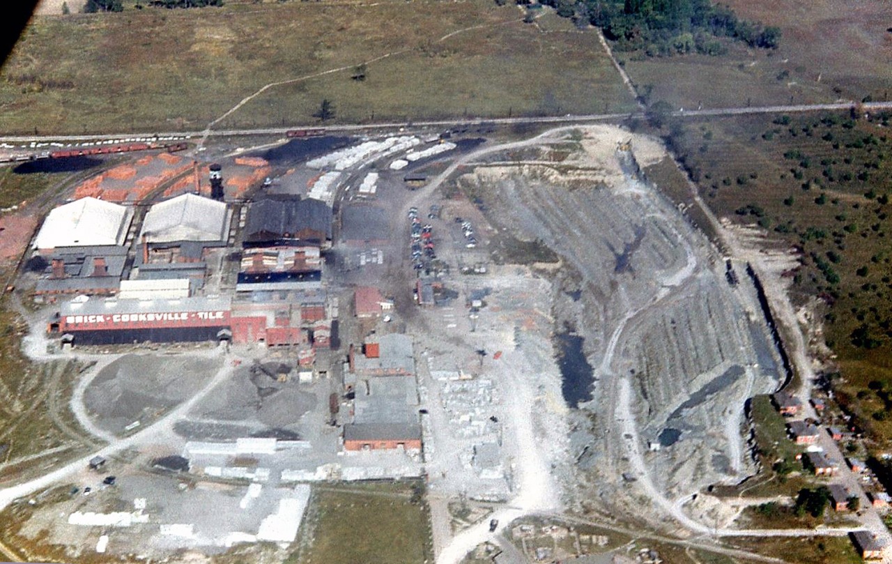
Caption: Out flying with a friend offered this aerial view of the Cooksville Brick Company's plant and quarry pit in Cooksville in 1953 (by then part of Toronto Township, the present-day Mississauga). CP's Galt Sub mainline runs along the north end of the property, and Dundas (Highway 5) runs along the bottom out of view. The area northwest of Cooksville where the plant was situated was still relatively rural. At one time, Cooksville Brick was once the largest manufacturer of bricks in Canada, and there was another pit located just to the west on the property (out of frame) near the corner of Mavis and Dundas.

Dump cars filled with excavated quarry material are visible on sidings between the plant buildings, and 40' boxcars with their doors open and loaded with brick sit on sidings just south of the Galt Sub. Quarry trackage can faintly be traced in the pit, but for a better view see: http://www.railpictures.ca/?attachment_id=25546. Even one of Cooksville Brick's little black 0-4-0T switchers can be faintly spotted (at the north end, just south of the Galt Sub).

Photographer:
Bill Thomson [715] (more) (contact)
Date: 1953 (search)
Railway: Industrial (search)
Reporting Marks: Not Provided
Train Symbol: Not Provided
Subdivision/SNS: Cooksville Brick Company - CP Galt Sub (search)
City/Town: Cooksville (search)
Province: Ontario (search)
Share Link: http://www.railpictures.ca/?attachment_id=25923
Click here to Log-in or Register and add your vote.

7 Favourites
Photographers like Gold.Log-in or Register to show appreciation
View count: 2394 Views

Share this image on Facebook, Twitter or email using the icons below
Photo ID: 24774

Map courtesy of Open Street Map

Full size | Suncalc


All comments must be positive in nature and abide by site rules. Anything else may be removed without warning.

3 Comments
  1. Am I safe to assume that this is all close to 100% residential now?

  2. Pretty much Michael, like much of the former industrial lands in the GTA that had been redeveloped as the suburbs expanded.

  3. Wonderful shot.

Railpictures.ca © 2006-2024 all rights reserved. Photographs are copyright of the photographer and used with permission
Terms and conditions | About us