Welcome Visitor. First time here? Like what you see? Bookmark us for when you are bored, and check out 'top shots' and 'fantastic (editors choice)' in the menu above, you won't be dissapointed. Join our community! click here to sign up for an account today. Sick of this message? Get rid of it by logging-in here.


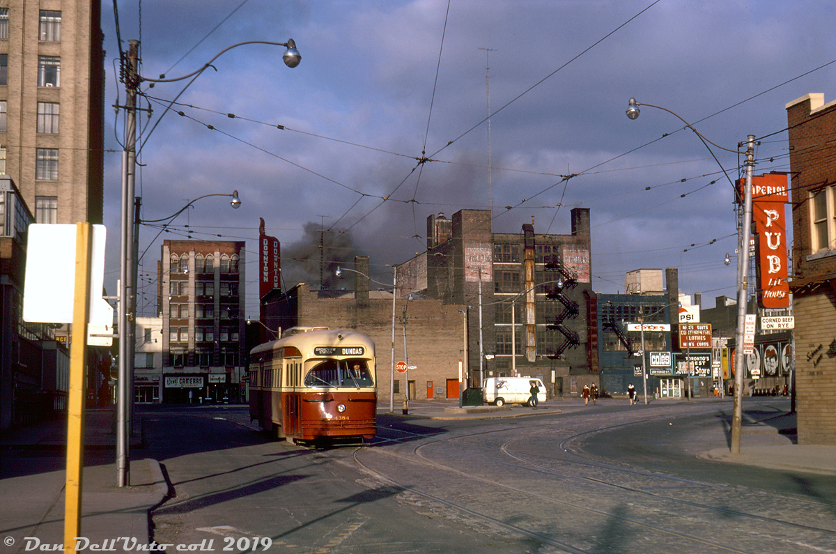
Dundas Square, 1970's style. TTC PCC 4384 operates on an eastbound run of the Dundas route, shown at Dundas & Victoria amid some morning unrest: smoke from an unspecified fire downtown (not the famed Eatons fire that took place a number of years later) is visible in the background, and whatever the incident was probably necessitated diverting Dundas cars down to Queen and across to get around it. 4384 is shown on the short connecting track between Victoria and Dundas proper, meaning it has just come up from Queen via Victoria, and is resuming regular routing on Dundas bound for Broadview Subway Station. Due to the lack of foot and auto traffic, it's possible that this was taken on a weekend.

Everything in this scene has changed dramatically in the years and decades that followed, and anyone frequening this area of Toronto today would be hard-pressed to find much of old still recognizable (the big 10 Dundas Street East blob doesn't help). Behind the streetcar to the right are the original Dundas Square retail/commercial buildings that once occupied the site, bounded by Yonge, Dundas, Victoria and Dundas Square. Tenants included Cole's (books), a Howard Johnson's, and the Downtown Theatre (whose street-side marquee signage is visible poking up). The whole "square" of buildings was demolished as part of a Yonge Street revitalization plan in the late 90's, and the current public square was built in its place.

Wong's Cameras and the whole block in the distance on the west side of Yonge Street (that also included a Japan Camera Centre) were on borrowed time and would be demolished in the early 70's to make way for the new Eaton Centre shopping mall development.

The familiar illustrations outside the Brown Derby Tavern are visible on the right, in the distance at the corner of Dundas & Yonge (present for a few more years until redevelopment). And just squeezed in is the signage of the Imperial Pub, long a favourite watering hole for nearby Ryerson Polytechnic/University students, and still present today.

Original photographer unknown, Dan Dell'Unto collection slide.
Copyright Notice: This image ©Unknown, Dan Dell'Unto coll. all rights reserved.


Caption: Dundas Square, 1970's style. TTC PCC 4384 operates on an eastbound run of the Dundas route, shown at Dundas & Victoria amid some morning unrest: smoke from an unspecified fire downtown (not the famed Eatons fire that took place a number of years later) is visible in the background, and whatever the incident was probably necessitated diverting Dundas cars down to Queen and across to get around it. 4384 is shown on the short connecting track between Victoria and Dundas proper, meaning it has just come up from Queen via Victoria, and is resuming regular routing on Dundas bound for Broadview Subway Station. Due to the lack of foot and auto traffic, it's possible that this was taken on a weekend.

Everything in this scene has changed dramatically in the years and decades that followed, and anyone frequening this area of Toronto today would be hard-pressed to find much of old still recognizable (the big 10 Dundas Street East blob doesn't help). Behind the streetcar to the right are the original Dundas Square retail/commercial buildings that once occupied the site, bounded by Yonge, Dundas, Victoria and Dundas Square. Tenants included Cole's (books), a Howard Johnson's, and the Downtown Theatre (whose street-side marquee signage is visible poking up). The whole "square" of buildings was demolished as part of a Yonge Street revitalization plan in the late 90's, and the current public square was built in its place.

Wong's Cameras and the whole block in the distance on the west side of Yonge Street (that also included a Japan Camera Centre) were on borrowed time and would be demolished in the early 70's to make way for the new Eaton Centre shopping mall development.

The familiar illustrations outside the Brown Derby Tavern are visible on the right, in the distance at the corner of Dundas & Yonge (present for a few more years until redevelopment). And just squeezed in is the signage of the Imperial Pub, long a favourite watering hole for nearby Ryerson Polytechnic/University students, and still present today.

Original photographer unknown, Dan Dell'Unto collection slide.

Photographer:
Unknown, Dan Dell'Unto coll. [992] (more) (contact)
Date: Circa April 1970 (search)
Railway: Toronto Transit Commission (search)
Reporting Marks: TTC 4384 (search)
Train Symbol: Dundas (ebnd to Broadview Stn) (search)
Subdivision/SNS: Dundas St. E & Victoria St. (search)
City/Town: Toronto (search)
Province: Ontario (search)
Share Link: http://www.railpictures.ca/?attachment_id=39305
Click here to Log-in or Register and add your vote.

10 Favourites
Photographers like Gold.Log-in or Register to show appreciation
View count: 2560 Views

Share this image on Facebook, Twitter or email using the icons below
Photo ID: 38111

Map courtesy of Open Street Map

Full size | Suncalc


All comments must be positive in nature and abide by site rules. Anything else may be removed without warning.

2 Comments
  1. Amazing change. It is a wonder anyone can keep track of it all.

  2. Wow, nothing but the Imp remaining today. I wondered what ‘the square’ used to look like. Thanks

Railpictures.ca © 2006-2024 all rights reserved. Photographs are copyright of the photographer and used with permission
Terms and conditions | About us