Welcome Visitor. First time here? Like what you see? Bookmark us for when you are bored, and check out 'top shots' and 'fantastic (editors choice)' in the menu above, you won't be dissapointed. Join our community! click here to sign up for an account today. Sick of this message? Get rid of it by logging-in here.


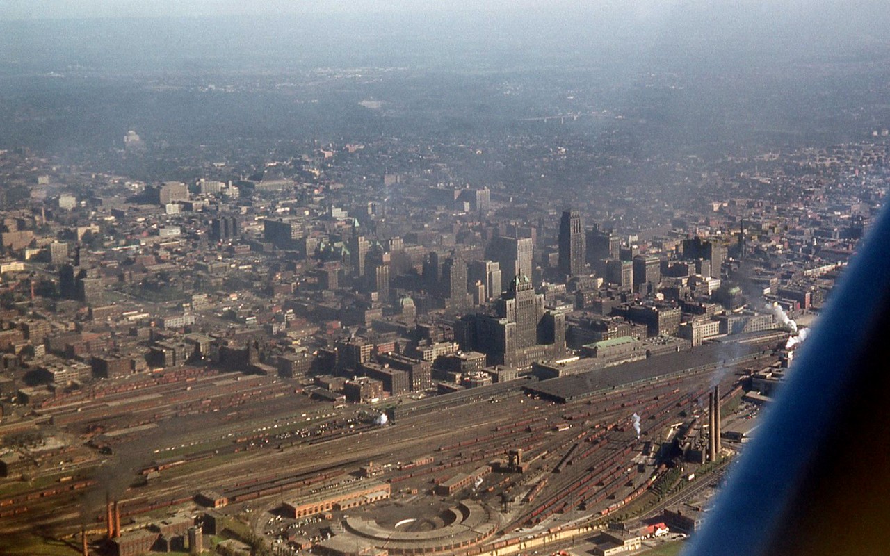
An aerial view of Toronto in 1953, showing some of the downtown railway lands and facilities that have long-since vanished. I was invited by a co-worker to join him for a flight from the Island Airport (he was trying to put in flying hours) but I could only get one shot before he headed for the rural areas. Steam is still going strong, evident by at least four wisps of white smoke from steam locomotives in the area.Visible at the bottom are Canadian Pacific Railway's John Street facilities, including the roundhouse, coachyard, stores building, passenger car servicing facilities and coaling tower. Union Station with its train shed, main buildings, and CNR & CPR express sheds at either side, is present near the middle in front of the towering CPR Royal York Hotel. The smokestacks at the bottom right are for the Central Heating Plant, that used to provide steam heat to various downtown buildings including the Royal York, Union Station and John St. Roundhouse. At the bottom left are some buildings part of CNR's Spadina roundhouse facilities (out of frame). Above that are various yards, including CNR's old freight sheds north of Front Street, and CPR's Dominion Express freight sheds at Simcoe and Wellington (note all the boxcars spotted at sidings).City-wise, the office tower boom of later decades had yet to begin, with the tallest building at the time being the Canadian Commerce Bank Building (the tallest building in the British Commonwealth, and also taller than the nearby Royal York Hotel). The Canada Life building is visible at the left-middle along University Avenue, Maple Leaf Gardens is prominent further away from downtown, and in the distance in the upper right, one can see the Prince Edward Viaduct carrying Bloor Street over the Don Valley.More in downtown Toronto:Bathurst Street in 1958: http://www.railpictures.ca/?attachment_id=15641Bathurst Street in 1979: http://www.railpictures.ca/?attachment_id=22282
Copyright Notice: This image ©Bill Thomson all rights reserved.


Caption: An aerial view of Toronto in 1953, showing some of the downtown railway lands and facilities that have long-since vanished. I was invited by a co-worker to join him for a flight from the Island Airport (he was trying to put in flying hours) but I could only get one shot before he headed for the rural areas. Steam is still going strong, evident by at least four wisps of white smoke from steam locomotives in the area.

Visible at the bottom are Canadian Pacific Railway's John Street facilities, including the roundhouse, coachyard, stores building, passenger car servicing facilities and coaling tower. Union Station with its train shed, main buildings, and CNR & CPR express sheds at either side, is present near the middle in front of the towering CPR Royal York Hotel. The smokestacks at the bottom right are for the Central Heating Plant, that used to provide steam heat to various downtown buildings including the Royal York, Union Station and John St. Roundhouse. At the bottom left are some buildings part of CNR's Spadina roundhouse facilities (out of frame). Above that are various yards, including CNR's old freight sheds north of Front Street, and CPR's Dominion Express freight sheds at Simcoe and Wellington (note all the boxcars spotted at sidings).

City-wise, the office tower boom of later decades had yet to begin, with the tallest building at the time being the Canadian Commerce Bank Building (the tallest building in the British Commonwealth, and also taller than the nearby Royal York Hotel). The Canada Life building is visible at the left-middle along University Avenue, Maple Leaf Gardens is prominent further away from downtown, and in the distance in the upper right, one can see the Prince Edward Viaduct carrying Bloor Street over the Don Valley.

More in downtown Toronto:
Bathurst Street in 1958: http://www.railpictures.ca/?attachment_id=15641
Bathurst Street in 1979: http://www.railpictures.ca/?attachment_id=22282

Photographer:
Bill Thomson [715] (more) (contact)
Date: 1953 (search)
Railway: Canadian Pacific (search)
Reporting Marks: Not Provided
Train Symbol: Not Provided
Subdivision/SNS: CPR John Street Roundhouse (search)
City/Town: Toronto (search)
Province: Ontario (search)
Share Link: http://www.railpictures.ca/?attachment_id=23318
Click here to Log-in or Register and add your vote.

27 Favourites
Photographers like Gold.Log-in or Register to show appreciation
View count: 21766 Views

Share this image on Facebook, Twitter or email using the icons below
Photo ID: 22170

Map courtesy of Open Street Map

Full size | Suncalc


All comments must be positive in nature and abide by site rules. Anything else may be removed without warning.

8 Comments
  1. Great Vantage point Bill! Must have been quite the adventure.

  2. “The Big Smoke’ !!! Sure looks a lot different from your perspective than from the tourist brochures of the day. Love this shot.

  3. Great shot of the city. Thanks for being brave enough to go up and thanks for posting it over 60 years later.

  4. Well, this will keep me busy for a while. I can see two of the buildings I used to work in. Looks to be a good layer of soot on the Royal York.

  5. Excellent shot Bill.

  6. The local flora and fauna sure as heck doesn’t look like this anymore, but still this was made 25 years before I was even thought of.

  7. I’d like to point out this is the highest viewed photo as of 2018

  8. Never noticed how prominent the Ford Hotel and Maple Leaf Gardens were on the skyline before.

Railpictures.ca © 2006-2024 all rights reserved. Photographs are copyright of the photographer and used with permission
Terms and conditions | About us